Search by category, route or point of interest

Routes and points of interest Agenda and events contact
English
  • català
  • español
  • français

Filter routes

Sport

hiking

Trail Running

Skimo

Road bike

Mountain bike


Land

The terrain is determined by distance, positive slope and terrain.

Track routes, trails or obvious traces in low or medium mountains.

Routes in medium or high mountain terrain without technical steps.

Routes in medium or high mountain terrain with technical climbing steps.


Route distance

0.173 km - 27.771 km

route gradient

0 m - 2187 m

Duration approx. of the route

0 - 9h
Reset filters

Filter Points of Interest

Category

Reset filters
Show the list

Camí Ral de la Massana

Simple
Favorite
Capella de Sant Antoni de la Grella de la Massana, Edifici adossat a la roca de les gorges del riu Valira d’Orient. Capella d’origen romànic, reconstruïda pràcticament en la seva totalitat. Dedicada a Sant Antoni Abat, patró dels traginers, a qui invocaven abans de passar per aquest mal pas engorgat.
Passem per la nova passarel·la del Camí Ral de la Massana. Riu Valira del Nord
Pont Romànic de Sant Antoni de la Grella de la Massana, el pont passa per damunt del riu Valira del Nord i segueix el camí ral que unia la parròquia amb Andorra la Vella. La seva construcció és d'origen medieval i va ser refeta a la meitat del segle XX. Als voltants del pont es troba la capella de Sant Antoni de la Grella, originàriament romànica i restaurada a la dècada dels 40.
El pont de Sant Antoni de la Grella és una construcció molt senzilla, amb només un arc de mig punt rebaixat, una calçada totalment empedrada i una petita muralla. Té una alçada de 5,55 metres i una longitud de 21,20 m.
Cal indicar que aquest pont està dedicat a Sant Antoni Abat, patró dels "traginers", que eren els homes que baixaven mercaderies pel riu amb les seves embarcacions. Camí Ral
Vistes del Valira del Nord passem pel pont de la nova passarel·la del Camí Ral de la Massana. Petita zona al costat de la carretera on trobem un oratori i on podem asseure una estona, tenim bancs i taules. Camí Ral Les Moles d’Anyós, reconstrucció de les antigues moles del poble, centre d'interpretació. Camí Ral
Show +10 photos

distance · 6,1 Km
duration · 1h 50min
Elevation Gain · + 373
Circular · No

General Description

Recorregut: Ruta lineal que transita pel camí Ral, sempre pel costat del riu Valira d'Orient, acompanyats del seu relaxant so i la seva frescor, és un itinerari fàcil i pla, perfecte per passejar en família.

Observacions: Ruta molt assequible per iniciar-se.
Podem deixar el vehicle a l'aparcament del Prat del Molí.
Trobem una font d'aigua en arribar a l'església de Sant Antoni i aquesta serà l'única de tot el recorregut.

Ascens: Comencem la ruta caminant per un tram de carretera, l'antic camí Ral, seguidament agafarem el camí de les Gravades que ens enllaça amb el nou camí Ral per a vianants. En aquest caminarem pel costat del riu Valira d'Orient durant tota l'estona, segurament compartirem ruta amb més gent, i també coincidirem amb algun practicant de bicicleta. L'últim tram passarem per les Moles d'Anyós i més tard per l'Església de Sant Antoni de la Grella, on hi ha la font d'aigua, i si continuem creuarem el Pont Romànic de Sant Antoni de la Grella i en uns metres arribarem a l'Oratori de Sant Antoni, lloc on girem i tornem amunt pel mateix camí que ens ha portat fins aquí.


Turisme La Massana Comú de La Massana
Report incidence
Mostra el llistat Mostra el llistat
​

Safety tips

Enjoy the mountain safely

Mountain tours can be dangerous, which is why it is your responsibility to take all the necessary measures to safeguard your safety and integrity.

1. Preparation of the itinerary

Check the weather forecast before your departure

Take into account your physical condition and your experience in the environment

Consult the avalanche danger bulletin in winter times

Plan a suitable route knowing shelter points

2. Essential material

Bring the appropriate material for the activity and weather conditions

The rucksack cannot lack drink and food adapted to the departure

Don't forget to check beforehand that the DVA, Shovel and Probe are working

3. Mountain rescue

In the event of an accident or rescue in the mountains, call the emergency number.

112

The information and/or data set out on this page are not binding, although they may guide you during your journey. However, said information and/or data will not replace the need for experience, training and/or the support of a professional when organizing your tour. Therefore, this page will not be responsible for safeguarding its security and integrity during its journey.

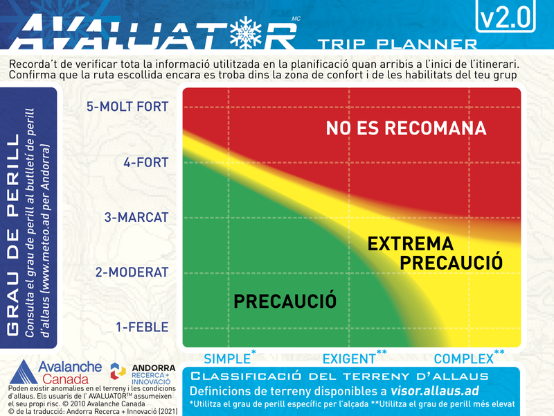
evaluator

What is ATES mapping?

The Avalanche Terrain Exposure Scale (ATES by its acronym in English) is a tool that allows you to evaluate, describe and communicate how prone the terrain is to being affected by avalanches, without taking into account variable snow-meteorological factors.

The ATES classification was developed in 2004 by Parks Canada following an accident in which seven teenagers died, probably due to a bad choice of route. Since then, this scale has been applied to several mountain ranges in Canada and New Zealand.

In the Pyrenees, this project has been developed in the Lauegi Center of Aran, in Tavascan, in some sectors of the Aragonese Pyrenees and in Andorra.

To carry out this classification, the technicians take into account different variables such as the slope, the density of the vegetation, the traps in the terrain or the frequency and size of expected avalanches, among others.

The final product is an invariant map in which the alluvial terrain is divided into three classes.

evaluator
What are the types of terrain?
Simple

Exposure to steep slopes and forest terrain. Some forest clearings may involve areas of infrequent avalanche arrivals. Many options to reduce or eliminate exposure

demanding

Exposure to well-defined avalanche path zones, exit zones or traps. There are options to reduce or eliminate exposure by careful route finding

Complex

Exposure to multiple and overlapping avalanche path zones or to large areas of open and sloping terrain. Multiple avalanche start zones with traps below. Minimal options to reduce exposure

For more information visit the website allaus.ad a project of Andorra Research + Innovation