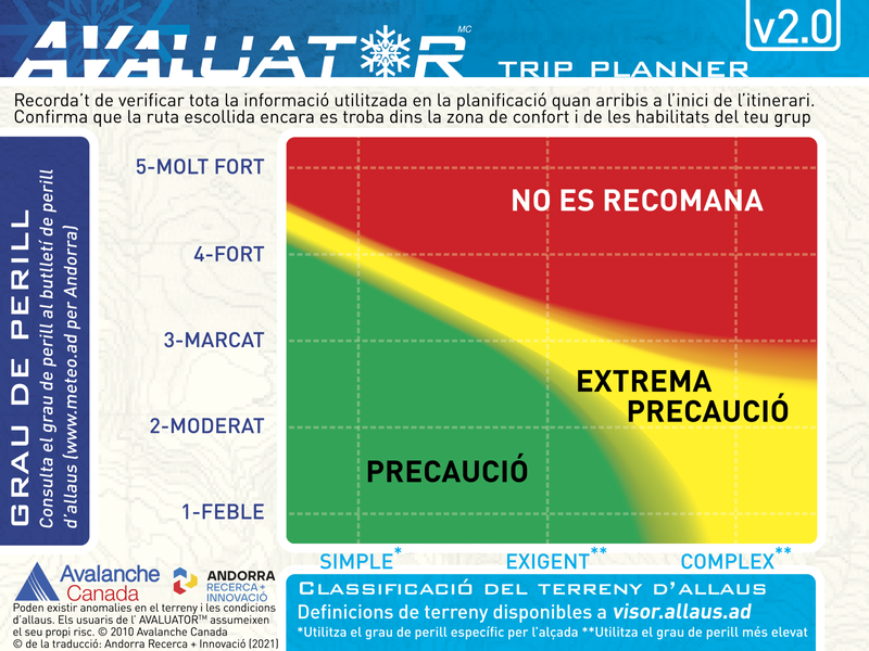
What is ATES mapping?
The Avalanche Terrain Exposure Scale (ATES by its acronym in English) is a tool that allows you to evaluate, describe and communicate how prone the terrain is to being affected by avalanches, without taking into account variable snow-meteorological factors.
The ATES classification was developed in 2004 by Parks Canada following an accident in which seven teenagers died, probably due to a bad choice of route. Since then, this scale has been applied to several mountain ranges in Canada and New Zealand.
In the Pyrenees, this project has been developed in the Lauegi Center of Aran, in Tavascan, in some sectors of the Aragonese Pyrenees and in Andorra.
To carry out this classification, the technicians take into account different variables such as the slope, the density of the vegetation, the traps in the terrain or the frequency and size of expected avalanches, among others.
The final product is an invariant map in which the alluvial terrain is divided into three classes.
evaluator

What are the types of terrain?
Simple
Exposure to steep slopes and forest terrain. Some forest clearings may involve areas of infrequent avalanche arrivals. Many options to reduce or eliminate exposure
demanding
Exposure to well-defined avalanche path zones, exit zones or traps. There are options to reduce or eliminate exposure by careful route finding
Complex
Exposure to multiple and overlapping avalanche path zones or to large areas of open and sloping terrain. Multiple avalanche start zones with traps below. Minimal options to reduce exposure
For more information visit the website allaus.ad a project of Andorra Research + Innovation


 Routes and points of interest
  Agenda and events
  contact


